 It's been a few very busy days, together with such pathetic internet through-put pretty much everywhere that I didn't even want to try posting. Beirut is like that: the internet, even when it's working, will suddenly slow to a crawl and stay that way for days. Last week the pain actually drove me to call the company, Cyberia (aptly chosen name, were it spelled slightly differently), that supplies my home connection. After the usual transition from Arabic to English or French I discovered that 'very sorry sir, we are having broblems on our system. It will soon be fixed, inshallah.'
There's no 'p' sound in Arabic, so 'problems' becomes 'broblems'. Inshallah means 'hopefully'. It also could mean 'it's out of our hands and may be for the rest of eternity'. And in this case the problem went on for days. In fact, things are still not back to normal.
Of course, there's the cafe I'm currently sitting in, where I often come when the internet gets so bad at home that work becomes impossible. And, at the moment, all is well. The other day, though, things suddenly got really, really bad. To the point where I was debating going back home! The staff kept rebooting the router and the modem and I could see them talking on the phone several times. It finally transpired that someone just across the street in possession of the password had opened up a connection and was hogging all our bandwidth. A new password fixed the problem, but not before about 2 hours had gone into problem-solving.
Anyway, so much for technical issues. In the next day or two I have a couple of new things on the way, but first I decided to do another travelogue. The other day May and I jumped into the car yet again and finally made the long-postponed trip down south to Jezzine. The photos came out quite nicely, so I thought I'd take the opportunity to give a bit of a feel for Lebanon's topography. A lot of people think the Mideast is made up of desert and scrub, as in much of Syria and Iraq. Others might have a biblical image of the low hills and coastal plains of Palestine. Lebanon is quite different from either of these Mideasts, and quite spectacular topographically.
At the same time, as I mentioned in my travelogue to Byblos, there have been lots of changes in the last 40 years and the low cities and small villages of the Lebanon I knew then have given way in many places to large urban agglomerations whose uncontrolled scale dwarfs and overwhelms the natural environment. Fortuantely, it turns out that the road to Jezzine has been largely spared....so far.
Jezzine is the door to the South of Lebanon. It's a largely Christian town located at the head of an enormous valley that stretches northward through the hills and mountains of the Shouf region where I used to live. In fact, most of the trip will run through very familiar territory for me. The first big stop is Baaqline, where I used to live.
The trip begins with a short run along the coast road through the village of Khalde to Damour, where we head east into the Shouf mountains. Here's the coastal 'village' of Khalde, just south of the airport:

Back when I lived here, it was barely big enough to merit being called a village.
A few minutes later we reach what used to be the Christian village of Damour, where we used to stop and buy our vegetables before heading up to Ba'aqline. Damour is a town with a tragic history of its own. After the terrible massacres of Palestinian refugees at Tel el Zaater camp by Christian militias, Damour was overrun during the civil war by forces of the Lebanese left and the PLO. Many of its inhabitants were massacred and most of the rest of its inhabitants were driven out. Since the end of the war many have returned, and what used to be a small village has now become essentially a suburb of Beirut:

Visually, things start to get better as soon as we turn off the coast road at Damour and head east. The matresses look relaxing:

A few moments later, a huge relief. This looks exactly as I remember it, completely unchanged and just as beautiful as it used to be... the banana and citrus plantations of Wadi Damour:

From Wadi Damour it's uphill all the way. Here are a few pics to give a feeling:
 |
| Leaving Damour and heading uphill... |
 |
| And more uphill... |
 |
| And even more uphill... |
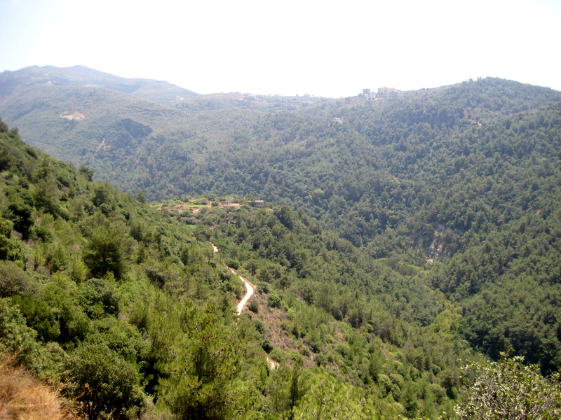
Until, from the former village - now town - of Kfar Heem we get a good view of the rest of the climb. Baaqline is just visible at the top of the photo, the slowly rebuilding village of Deir Dourit is below. Deir Dourit was a stronghold of the Christian militias during the civil war. After the assassination of Druze leader Kamal Joumblatt in 1977 - almost certainly at the hands of the Syrians - Druze from Baaqline and other villages descended upon their Christian neighbors, killing several hundred and virtually wiping out Deir Dourit. Like so many things here in Lebanon, tragedy lurks just below the surface, no matter how bucolic:

About half an hour later, we arrive in my old village, Ba'aqline. Incredibly, the place looks almost unchanged:

And, indeed, we are in Druze country:

The view of the hills behind the village is just as green and rural it always was:

On the other side of Baaqline we have the village of 'Ain Baal. I always loved the place because it instantly tells you that the place name is not hundreds, but thousands of years old. It means, simply, 'the spring of Ba'al', who was Yahweh's main competitor in the god business back when. In other words, the place is as old as the Bible!
Next to 'Ain Baal is Semqaniyeh, which also used to be a tiny village. It's now become a suburb of Baaqline, more or less. What Yahweh and Baal together couldn't accomplish, man has done in just a few years. And just beyond, the village of Beqaata was transformed during the war into nothing less than a city. This happened because travel to Beirut was impossible for long periods, so the Shouf needed an urban center of its own to supply the region. Thank god (Baal, Yahweh, Allah) they didn't pick Baaqline:
 |
| The new city of Beqaata. What used to be Semqaniyeh is in the distance. |

After 'Ain Baal, Semqaniyeh and Beqaata, it's really the Shouf as it used to be. Here's the view looking south. The last ridge is approximately our destination: Jezzine. Beyond that, the mountains grow smaller and it's probably no more than 20 miles or so as the crow flies to the beginning of the Galilee. Lebanon really is a tiny country:

 |
| Sheer cliffs that have doubled for 1000s of years as terraces |
 |
| In the wadi before the climb to Mukhtara |
The village of Mukhtara is the feudal seat of the Joumblatt family - which could also be spelled 'Jounblatt family', 'Junblat family', 'Jumblatt family', and so on. Like everybody else in Lebanon, the Druze used to be fiercely divided into factions. For several decades, since the time of Kamal Jounblatt, the Joumblatts have enjoyed a political ascendancy. The village is one of the best-preserved in the area. Here's the road up to the village from the wadi:

And here's a view of the village from the hillside opposite:
 |
| Muhktara |
And, a view looking up at the Junblatt palace, much enlarged over the decades by Walid Junblatt, Kamal's son:

After Mukhtara, there's a series of small villages, as the countryside gets starker and more sharply defined. Here's a view looking back north at the relatively green and lush northern Shouf:

And now the wadi starts to deepen progressively into an enormous gorge:


At the same time, the lush green of the Shouf begins to recede as we approach Jezzine. At Jezzine the Shouf ends and the topography with it. Instead of the deep north-south crease of the Shouf, the area beyond it is more oriented east-to-west, with the valley of the Litani river cutting across it. This is a view looking back north from near Jezzine:

Now the last few kilometers, on a newly-asphalted road:
 |
| What's wrong with this picture? Oh, yeah...a sheer cliff-edge for several kilometers and no guard rail! |
Finally, Jezzine! And a couple of views looking back north, really quite spectacular:


No comments:
Post a Comment